PLATE BOUNDARIES
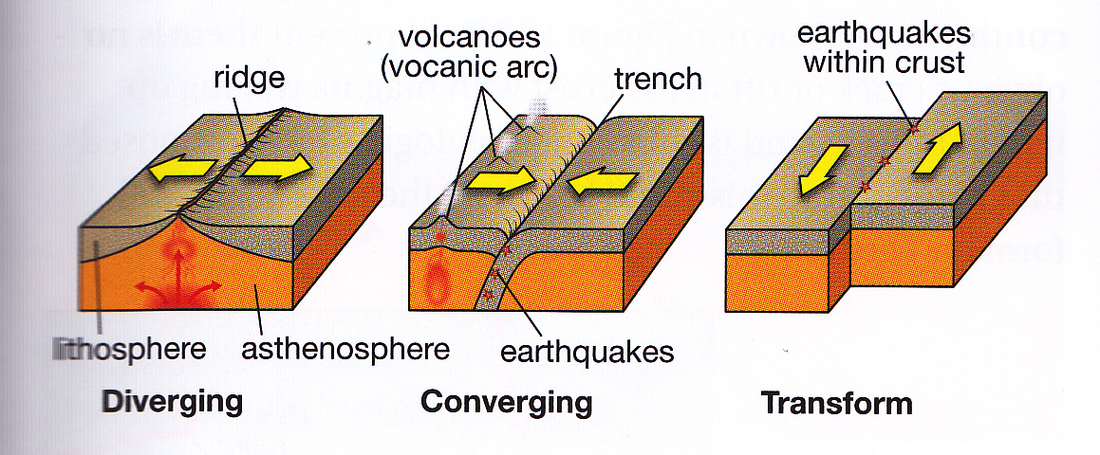
Tectonic plates move in three different ways at the boundaries between them. These are:
* diverging boundaries – where the plates are moving apart from each other
* converging boundaries – where the plates are colliding with each other
* transform boundaries – where the plates are sliding past each other
|
DIVERGING BOUNDARIES
To diverge means to separate. Diverging boundaries are where the plates are moving apart from each other in opposite directions. The mid-ocean ridges form a diverging boundary. Q. What would you expect to see at a mid-ocean ridge, and where the plates diverge? When the plates separate, there is a rift (deep crack) between them. Magma from the asthenosphere rises up into the rift and solidifies as it cools. This forms new boundaries. Wherever there is an ocean ridge, there must be plates that are diverging. Diverging boundaries also occur on land. The Mid-Atlantic Ridge runs right through the island of Iceland. Constant volcanic eruptions send magma up into the rift, new crust is being formed and the island is widening at around 2-5cm per year. This spread has formed the Atlantic Ocean. Diverging boundaries also seem to be forming in East Africa. A massive rift valley, called the Great Rift Valley, runs along the whole eastern part of the continent. At the moment there is no obvious crack or rift in the crust with magma welling up into it, but the land is subsiding. Geologists have proposed that in the future this could be where the next ocean will form on Earth. 
|
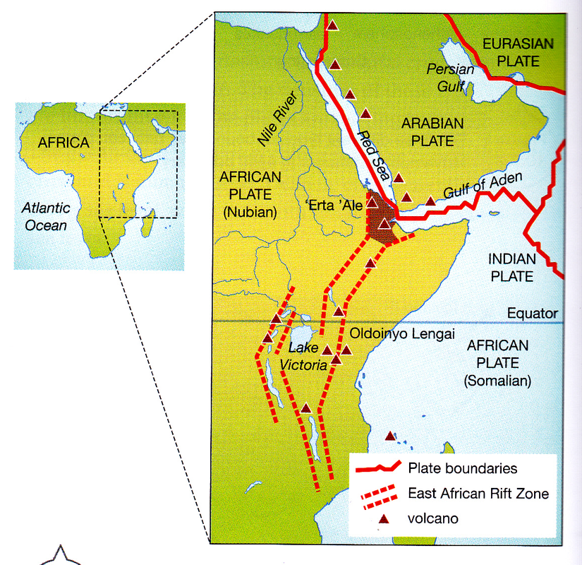
The Great Rift Valley of Africa could be the site of the next ocean to form on Earth. The dashed lines show where the edges of the rifts (cracks) are. The red triangles show active, dormant and extinct volcanoes.

|
Iceland sits on top of the Mid-Atlantic Ridge, a vast volcanic mountain chain that is entirely submerged except in Iceland. The Mid-Atlantic Ridge marks the plate boundary between the North American plate to the west, and the Eurasian plate to the east.
You can clearly see it in these pictures. Geologists are able to examine these diverging boundaries first hand.
Click on the image on the left hand side to see a video about this unique part of the world.
You can clearly see it in these pictures. Geologists are able to examine these diverging boundaries first hand.
Click on the image on the left hand side to see a video about this unique part of the world.
|
CONVERGING BOUNDARIES
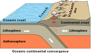
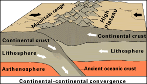
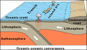
Converging boundaries occur when two plates are colliding into each other. To converge means to come together. These collisions form many land features such as mountains. The features that are formed will depend on what types of crust collide. Rock is destroyed at converging boundaries. What happens if oceanic crust and continental crust collide? If oceanic crust is colliding with continental crust, then the denser oceanic plate sinks under the lighter continental plate. This is known as subduction. The continental plate becomes distorted and forms fold mountains and volcanoes. Where the oceanic plate subducts under the continental plate, a deep ocean trench is formed. The plate that subducts is diving down deep into the mantle. Crust is being destroyed as it subducts as the heat in the mantle, along with the friction of the plates colliding, is enough to melt the crust and form magma. What happens when two continental plates collide? When two continental plates collide, both are pushed upwards as they are the same density. This forms incredibly high mountain systems. The best known example is where the Indian Plate is colliding with the Eurasian Plate. This has formed the highest mountain range on Earth, the Himalayas. The highest mountain, Mt. Everest, stands 8,848 metres above sea level and was formed by this process. What happens when two oceanic plates collide? When two oceanic plates collide, one always subducts under the other. The faster moving plate subducts and forms a deep trench. The descending plate melts and is destroyed and this magma rises up to the surface forming a chain of volcanic islands, called an island arc. An island arc is a long, curved chain of oceanic islands that display intense volcanic and seismic activity and orogenic (mountain-building) processes. Prime examples of this form of geologic feature include the Aleutian-Alaska Arc and the Kuril-Kamchatka Arc. |
|

Notably, the Himalayas are the youngest mountain ranges on the planet, and consist mostly of loose sedimentary material. Due to the continuing collision of the continental plates beneath the Eurasian and Indian subcontinent, the Himalayas are continuing to shift upward, growing ever larger and more formidable.
|
TRANSFORM BOUNDARIES
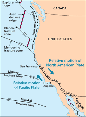
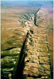
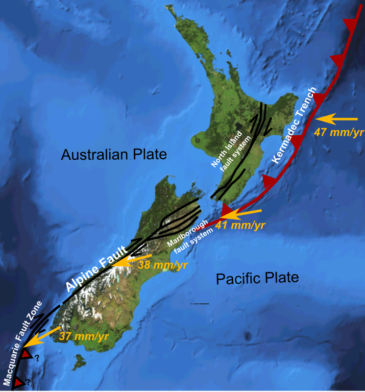
A transform boundary is where two plates are sliding parallel to each other but in opposite directions. The plates often move very slowly and then suddenly slip quickly past each other. This causes earthquakes. Most transform boundaries are on the ocean floor. On land, a transform boundary usually has fold mountains along its length and many cracks in the rock, called fault lines. Fold mountains are mountain ranges that are formed when two of the tectonic plates that make up the Earth's crust push together at their border. The extreme pressure forces the edges of the plates upwards into a series of folds. These fold mountains and fault lines are also evident under the ocean. Fault lines usually do not form one continuous crack in the crust along the plate boundary. Instead there are many cracks parallel to each other. You may have heard of the San Andreas Fault in California, USA. This fault is located where the Pacific Plate and the North American Plate move past each other. Los Angeles and San Francisco are built along the fault line, and have suffered massive earthquakes in the past when the plates slipped quickly. Another transform fault runs right through the middle of New Zealand due to the Australian Plate and Pacific Plate grinding against each other in opposite directions. Massive earthquakes have been recorded in New Zealand in recent years, most notably in Christchurch. However, movement of this transform boundary has also created the magnificent mountains of the South Island. Images below: Left: New Zealand's transform boundary showing the Alpine Fault and minor fault lines. Right: Snow-capped mountains of the Alpine Fault, New Zealand. Click on the image to view a short clip about New Zealand's fault lines and earthquakes. |
|
|

|
WE HAVE ALWAYS BEEN TOLD NOT TO PLAY WITH OUR FOOD BUT WHO CAN RESIST...

...Mars Bar Plate Divergence
|
|

...Mars Bar Plate Convergence
|
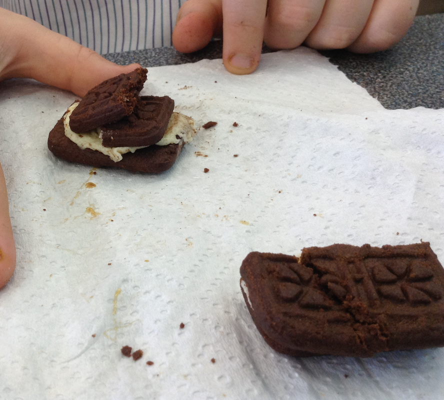
...a cream-filled chocolate biscuit subduction and transform boundary
HOW DO THE PLATE BOUNDARIES WORK TOGETHER?
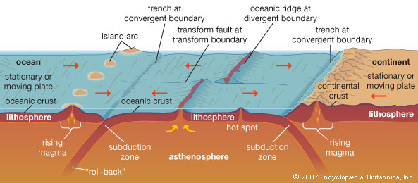
This image gives you an example of how all of the plate boundaries work together, along with their unique characteristics.

Click on this image to take you to the website of The Geological Society where you can learn more about Plate Tectonics
Information on this page has been taken from: Science Learning Hub; Pearson Science S.B. 9 textbook; http://kerdowney.com/tag/himalayas/; http://www.britannica.com/EBchecked/topic/295969/island-arc; and the website of The Geological Society - http://www.geolsoc.org.uk/Plate-Tectonics/Chap2-What-is-a-Plate; http://www.platetectonics.com/book/page_5.asp
Pictures on the page are from the Pearson Science 9 Student Book or Google images. Refer to references page on website for full details.
Pictures on the page are from the Pearson Science 9 Student Book or Google images. Refer to references page on website for full details.
